





Parts of the UK are bracing for an autumn chill as new weather maps highlight a dramatic mid-October freeze. Weather maps have turned a vibrant shade of purple, signalling an early-season “snow bomb” set to sweep across parts of northern Britain this weekend. According to new forecast charts from WXCharts, persistent wintry showers are set to strike early on Saturday morning (October 10). The precipitation overview map shows a patch of intense purple shading directly over North West Scotland around 6am UTC (7am BST), indicating early-morning snowfall over high ground and mountain regions. A second chart tracking minimum temperatures over a six-hour period leading up to Saturday midday shows thermometers plummeting across the Scottish Highlands and western hills.
While much of southern England and Wales will remain relatively mild with minimum temperatures lingering between 10C and 12C, Scotland will see a sharp drop into single digits. Broad swathes of the Scottish Highlands and Western Isles are projected to hover between 2C and 5C, with the coldest spots in central and north-western regions dipping near freezing at around 2C to 3C.
The core concentration of purple radar shading highlights snow falling over high ground across Ross and Cromarty and Sutherland in the North West Highlands. Meanwhile, cold, wintry showers and overnight temperatures averaging between 4C and 6C grip the Western Isles and Inner Hebrides.
Further inland, minimum temperatures will drop to a chilly 2C to 3C across the Grampian Mountains and Central Highlands, bringing a widespread frosty feel by dawn on Saturday, with the wider northern and central regions – including Perthshire, Inverness-shire, and Aberdeenshire – holding between 3C and 6C.
Widespread rain and shower bands elsewhere across the UK mean that while low-lying southern and coastal areas will experience typical damp October weather, the high country of Scotland is set for its first taste of winter.
A separate winter overview map for midday on Sunday (October 11) shows a green “546” thickness line cutting across northern parts of the UK, with an orange “564” line further south. These lines mark atmospheric temperature, where lower values signal colder air.
The green 546 contour represents cold polar maritime air capable of bringing wintry showers and hill snow, while the orange 564 line marks much milder air to the south, drawing a clear atmospheric divide across the country.
However, the Met Office makes no mention of snow for mid-October, forecasting changeable weather driven by low-pressure systems bringing wet, windy conditions – especially in the north and west – alongside temperatures that remain slightly above average overall.
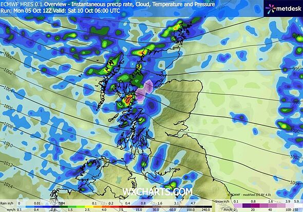
The snow will be concentrated in the northwest of Scotland for the time being (Image: WXCharts)
The Met Office’s long-range forecast for the period October 10 to October 19 reads: “It will likely be quite changeable through the middle of October, as a series of low pressure systems run across the North Atlantic, often to the north and northwest of the UK, bringing occasional bands of rain and strong winds, but interspersed with brighter and more showery conditions. Rain will be most prevalent across hills in the west and especially northwest, where above average rainfall is likely through this period.
“Longer drier interludes are more favoured in sheltered southern and eastern parts, but even here it is likely to be wetter than during recent weeks. Whilst brief cooler interludes are possible, temperatures are likely to be a little above average in many areas for the period as a whole.”
Regarding its long-range forecasting, the Met Office warns: “When looking at forecasts beyond five days into the future, the chaotic nature of the atmosphere begins to play a larger part – small events currently over the Atlantic can have potentially significant impacts on our weather in the UK and Ireland in several days’ time”.
Source: www.aol.co.uk