



Key Takeaways:
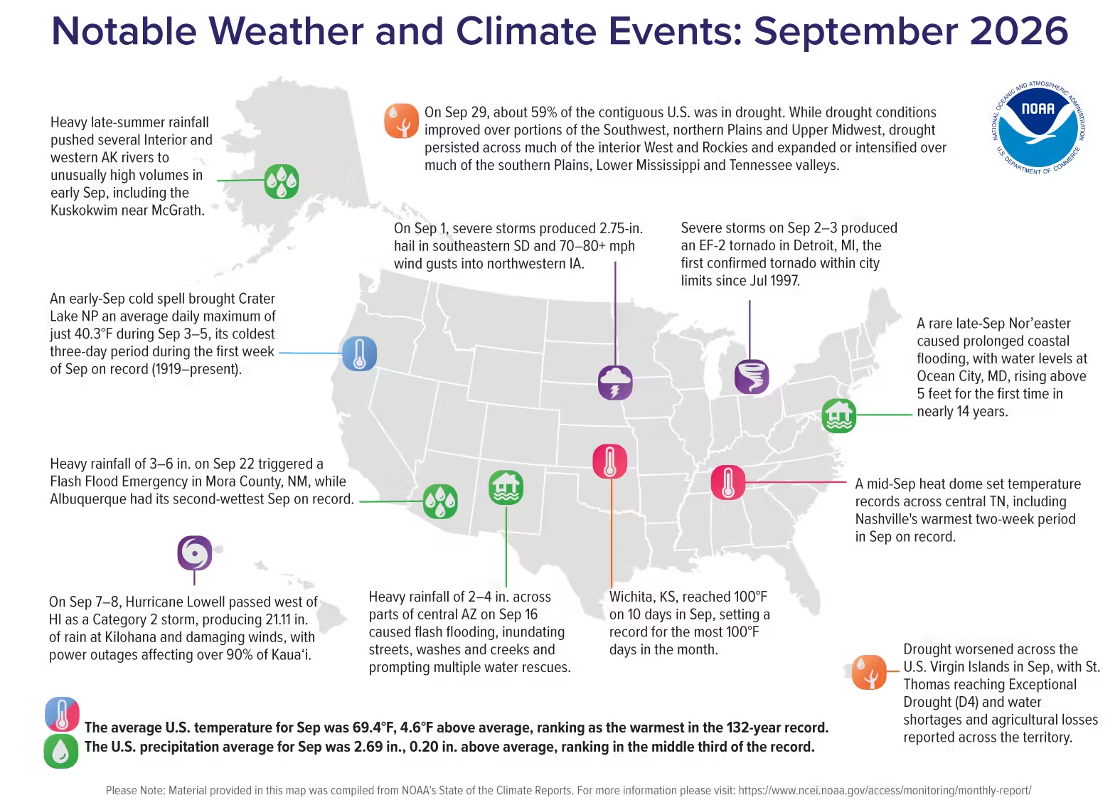
- Warmest September on record: September 2026 averaged 69.4°F, the warmest September on record (1895–present) for the contiguous U.S. (CONUS).
- Prolonged above-average temperatures: The CONUS monthly average temperature has been above the respective 20th-century average for the past 20 months (February 2025 to September 2026), with four months in 2026—March, July, August and September—ranking as the warmest on record.
- Drought expands across the South: Drought conditions expanded to cover 89% of the South region according to the September 29 U.S. Drought Monitorthe largest extent for the region since October 2000.
- Hawaiʻi exceptionally wet: Hurricane Lowell contributed to Hawaiʻi’s second-wettest September in the 36-year record.
- No Atlantic hurricanes through September: Eight named storms formed in the Atlantic basin through September, but none reached hurricane strength, the latest point in the season without an Atlantic hurricane in the satellite era (since 1966).
Other Highlights:
Temperature
The average temperature for the CONUS in September was 69.4°F, 4.6°F above the 20th-century average, making it the warmest September in the 132-year record, surpassing the previous record set in 1998 (68.95°F). Above- to much-above-average temperatures covered much of the interior U.S. and extended to the East Coast, with large portions of the southern and central Plains and the Mississippi Valley experiencing record-warm September temperatures. In contrast, parts of northern California and the Pacific Northwest recorded below-average temperatures. Eight states had their warmest September on record, with five—Arkansas, Illinois, Kansas, Missouri and Oklahoma—surpassing records dating to the 1920s or 1930s.

Nighttime minimum temperatures were especially notable: the CONUS average surpassed the previous September record, set in 2019, by more than 1.2°F. Based on county-average nighttime minimum temperatures for September, more than 30% of the CONUS area, home to an estimated 80 million people, experienced their warmest September nighttime temperatures on record.
Alaska’s average temperature was 42.5°F, 1.9°F above the 1925–2000 average, ranking in the warmest third of the 102-year record.
Hawaiʻi’s average temperature was 71.1°F, 2.1°F above the 1991–2020 average, ranking as the second-warmest September in the 36-year record. Minimum temperatures were especially notable, averaging 65.0°F, 3.6°F above average and the warmest September minimum temperatures on record.
Precipitation
Total precipitation averaged across the CONUS in September was 2.69 inches, 0.20 inch above the 20th-century average, ranking in the wettest third of the 132-year record. Above-average precipitation occurred across much of the northern tier, from the Northwest through the northern and central Plains, portions of the Upper Midwest, Great Lakes and Ohio Valley into the Northeast, while parts of the northern Great Lakes and far Northeast had below-average precipitation. Across the southern tier, much-above-average precipitation in the Southwest contrasted with below- to much-below-average precipitation across much of the South, middle Mississippi Valley and Southeast.

The Southwest received more than twice its average September precipitation, with Arizona and New Mexico each recording their second-wettest September. Arizona received 2.97 inches (251.7% of average), its wettest September since 1983, while New Mexico received more than 5 inches (303.6% of average), its wettest since 1941.
Alaska’s average precipitation was 4.74 inches in September, 0.17 inch above the 1925–2000 average, ranking in the middle third of the 102-year record. Above-average precipitation extended across much of the North Slope and the central and eastern Interior, with Fairbanks having its wettest September since 1925.
Hawaiʻi received 10.83 inches of precipitation in September, 6.42 inches above the 1991–2020 average, making it the wettest September since 2015. Year-to-date precipitation averaged 86.66 inches, 42.70 inches above average, making January–September the wettest such period on record.
Drought
According to the September 29 U.S. Drought Monitorabout 59% of the CONUS was in drought, about the same percentage as at the beginning of September. Drought persisted across much of the interior West and Rockies, portions of the northern Plains, Upper Midwest and far Northeast. While there were areas of improvement across parts of the Southwest, northern Plains and Upper Midwest, drought expanded or intensified over much of the southern Plains, Lower Mississippi and Tennessee valleys.
Monthly Outlook
October temperatures are favored to be above average across much of the West and extending through the northern Plains, as well as along the Gulf Coast region and Florida. Above-average precipitation is favored across much of the southern tier, while the Northwest, northern Rockies and Plains are favored to receive below-average precipitation. Southeastern Alaska is favored to be warmer and wetter than average. Visit the Climate Prediction Center’s Official 30-Day Forecasts for more details.
Drought is expected to persist over much of the Northwest, Great Basin and northern High Plains, while improvement is expected throughout much of the Southwest, southern Plains and Lower Mississippi Valley, as well as parts of the Southeast and far Northeast. Visit the U.S. Monthly Drought Outlook website for more details.
Significant wildland fire potential for October is above normal across portions of the western Great Basin, western Great Lakes, southern Plains, Lower Mississippi Valley and Puerto Rico. For additional information on wildland fire potential, visit the National Interagency Fire Center’s One-Month Wildland Fire Outlook.
For more detailed climate information, check out our comprehensive September 2026 U.S. Climate Report scheduled for release on October 14, 2026. For additional information on the statistics provided here, visit the Climate at a Glance and National Maps webpages.
Source: www.ncei.noaa.gov