



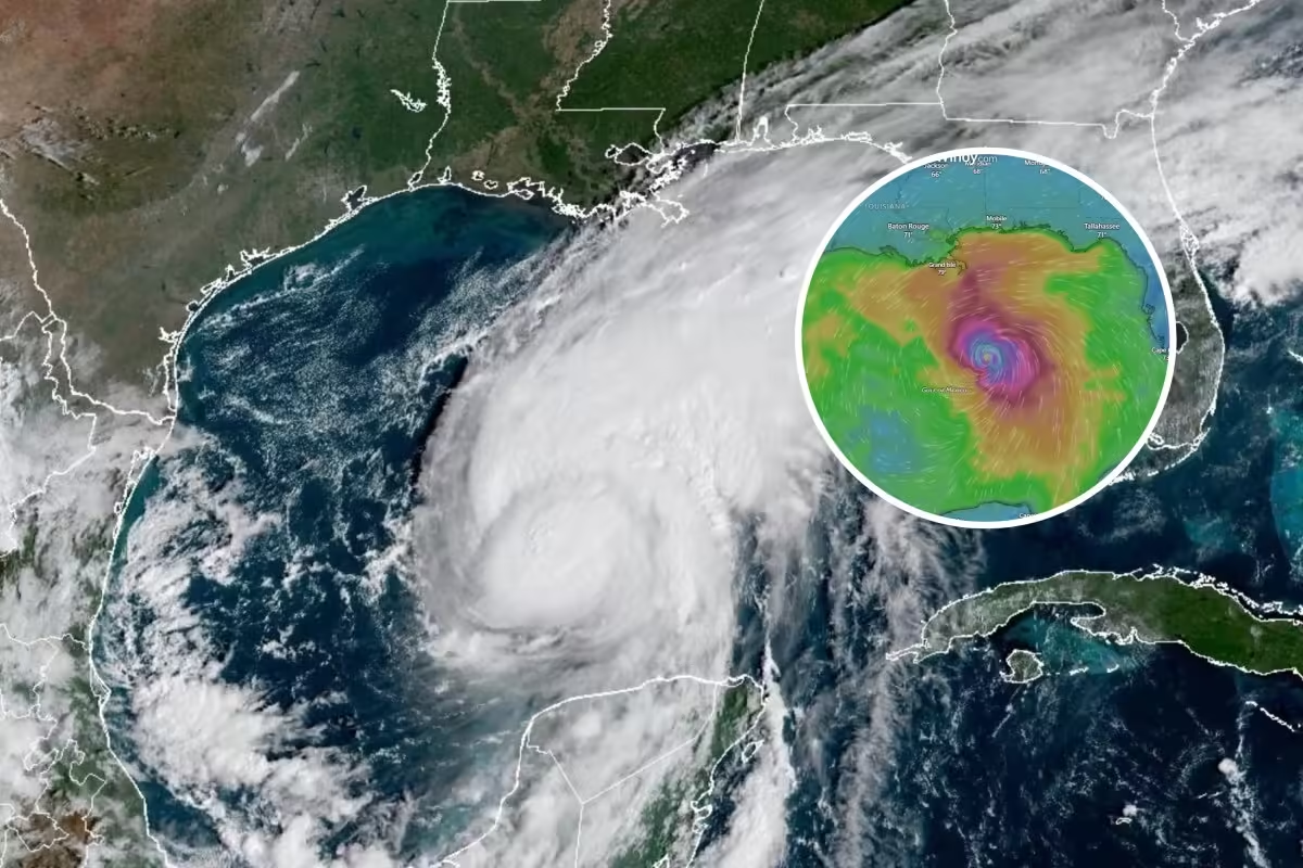

The first Atlantic hurricane of 2026 is set to make landfall along the Gulf Coast, with live maps continuing to track the storm’s progress as it pushes toward the United States.
Meteorologists have warned that Isaias, currently a “major” Category 3 hurricane, will lash the central Gulf Coast and parts of the Southeast with heavy rain and destructive winds, posing a serious flood and storm surge threat.
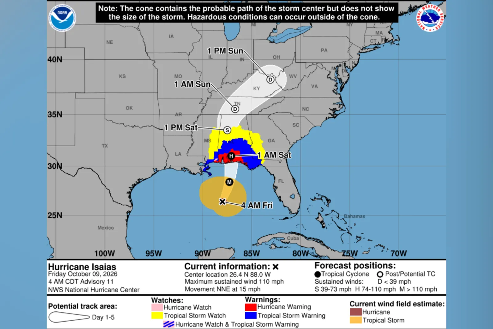
Forecast guidance from the National Hurricane Center (NHC) shows the hurricane will likely make landfall across the Florida Panhandle or Alabama late Friday or early Saturday. The agency cautioned that Alabama, Florida, and Georgia face a risk of tornadoes. High wind and tropical storm warnings have already been issued for Georgia.
President Donald Trump had plans to attend a college football game on Saturday in Tuscaloosa between the University of Alabama and the University of Georgia. In a post to Truth Social on Friday, he said he is canceling the trip because of the “huge” storm, adding that “it is important to have our wonderful First Responders, Law Enforcement, and others, focused on that Storm, and in no way be thinking about the safety, or presence, of the President of the United States, ME!”
Trump said that hopefully the game goes on despite the weather and that he will visit the two teams at a later date. The president also announced his new plan of traveling to Tennessee for a rally instead.
“With the storm making landfall at night, flooding of both storm surge and freshwater is more dangerous as it is more difficult to see the speed and depth of the water,” AccuWeather meteorologist Peyton Simmers told Newsweek on Thursday.
“Additionally, there is expected to be nocturnal tornadoes which can be extremely hard to see at night. These tornadoes can develop rapidly, so residents, even well away from the landfall point, need to have ways to receive warnings.”
Hurricane Isaiah Forecast
The NHC wrote in a forecast update at 2 p.m. ET on Friday: “Preparations against life-threatening storm surge and devastating winds should be completed in the next couple of hours.” The NHC added that Tropical Storm conditions are beginning along the northern Gulf Coast.
In a follow-up 3 p.m. ET update, the NHC said that conditions are rapidly deteriorating along the northern Gulf Coast. A wind gust of 47 mph was reported at Navarre Beach, Florida. Isaias’ maximum sustained winds are 120 mph, and the storm is about 90 miles south of Pensacola, Florida, and moving at 17 mph.
The agency said Isaias is likely to remain a dangerous hurricane when it makes landfall.
Through the weekend, the NHC expects 4 to 8 inches of rain across southern Alabama, the Florida Panhandle and Big Bend, and southwestern Georgia. Localized totals could also reach up to 15 inches, particularly within rain bands over the Panhandle and Big Bend.
Much of the rest of the Southeast is forecast to receive 2 to 5 inches of rain, although totals could reach 10 inches in some locations, especially across the southern Appalachians and coastal Carolinas, the NHC said.
The NHC said flash and urban flooding are likely across the region, with “considerable impacts” possible from southern Alabama and the Florida Panhandle into southwestern Georgia. River flooding is also expected and could be significant in some areas.
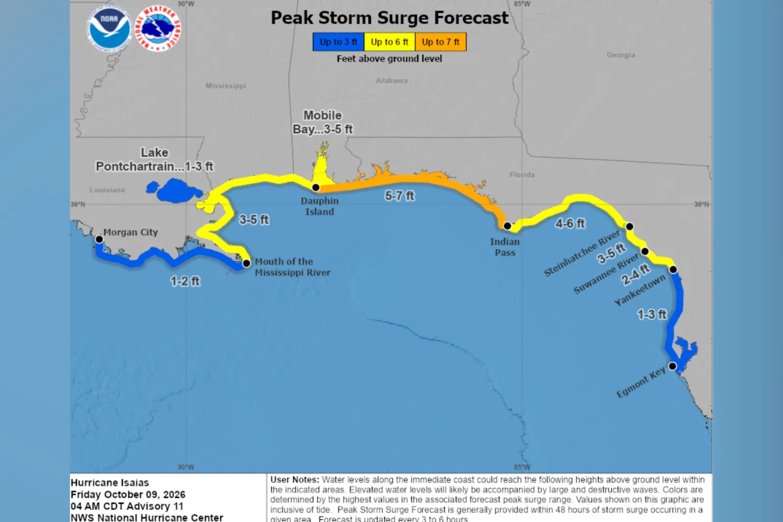
The agency said Isaias could also produce a dangerous storm surge that, combined with the tide, would flood normally dry coastal areas. If the peak surge coincides with high tide, water could reach 5 to 7 feet above ground level from Dauphin Island, Alabama, to Indian Pass, Florida, according to the NHC.
The NHC forecasts storm surges of 4 to 6 feet from Indian Pass to the Steinhatchee River; 3 to 5 feet from the Steinhatchee River to the Suwannee River, from the mouth of the Mississippi River to Dauphin Island, and in Mobile Bay; 2 to 4 feet from the Suwannee River to Yankeetown; and 1 to 3 feet from Yankeetown to Egmont Key, and around Lake Pontchartrain. Meanwhile, a surge of 1 to 2 feet is possible from Morgan City to the mouth of the Mississippi River.
Swells already affecting the western and northern Yucatán Peninsula are forecast to spread northward toward the Gulf Coast, producing potentially life-threatening surf and rip currents, it added.
Hurricane Isaias Warnings, Watches
The NHC said the following watches and warnings are in effect as of 4 a.m. CDT Friday:
Storm surge warning: mouth of the Mississippi River to the Suwannee River.
Hurricane warning: Ocean Springs, Mississippi, to the Bay/Gulf County Line, Florida.
Tropical storm warning: Jefferson/Plaquemines Parish Line, Louisiana, to west of Ocean Springs, Mississippi. Also east of Bay/Gulf County Line to Aucilla River, Florida.
Storm surge watch: Suwannee River to Yankeetown, Florida.
States Issue Emergency Declarations as Storm Nears
State-of-emergency declarations have been issued in several states ahead of Isaias’ arrival, with some areas also under evacuation orders.
In Florida, Governor Ron DeSantis declared a state of emergency for 27 counties: Baker, Bay, Calhoun, Citrus, Columbia, Dixie, Escambia, Franklin, Gadsden, Gilchrist, Gulf, Hamilton, Holmes, Jackson, Jefferson, Lafayette, Leon, Levy, Liberty, Madison, Okaloosa, Santa Rosa, Suwannee, Taylor, Walton, Wakulla and Washington.
DeSantis’ office said hundreds of Florida State Guards had been deployed to assist with pre- and post-landfall efforts.
In Alabama, Governor Kay Ivey declared a state of emergency for 40 Alabama counties on Wednesday. These affected counties include: Autauga, Baldwin, Barbour, Bibb, Bullock, Butler, Chambers, Chilton, Clarke, Choctaw, Coffee, Conecuh, Coosa, Covington, Crenshaw, Dale, Dallas, Elmore, Escambia, Geneva, Greene, Hale, Henry, Houston, Lee, Lowndes, Macon, Marengo, Mobile, Monroe, Montgomery, Perry, Pickens, Pike, Russell, Sumter, Tallapoosa, Tuscaloosa, Washington and Wilcox.
Georgia’s Governor Brian Kemp has declared a statewide emergency.
“As we prepare for Hurricane Isaias, I encourage all Georgians to prepare now by stocking up on food, batteries, flashlights, water, and other necessities in case of severe weather impacting communities Friday night through Saturday,” Kemp said.
The Associated Press reported that local residents in the storm’s expected area of impact were boarding up windows and stacking sandbags, and that some oil and gas producers had suspended operations in the Gulf.
How FEMA Says Residents Should Prepare
The Federal Emergency Management Agency (FEMA) urged Gulf Coast residents to sign up for local weather alerts and follow instructions from local officials. The agency also advised people to plan where they would go, travel options, and where they could stay if ordered to evacuate.
The FEMA also said residents should establish how to contact family and friends following a disaster, and to store enough food, water and other essentials to last several days.
What Is The Saffir-Simpson Scale?
The Saffir-Simpson Hurricane Wind Scale classifies hurricanes from Category 1 to Category 5 based on their maximum sustained winds, according to the National Oceanic and Atmospheric Administration.
Category 1 and 2 hurricanes have sustained winds of 74 to 95 mph, and 96 to 110 mph respectively. Category 3 hurricanes— the level at which storms become major hurricanes—have sustained winds of 111-129 mph.
Category 4 storms have winds of 130 to 156 mph, while Category 5 hurricanes have winds of 157 mph or higher.
Contact Newsweek editors on this story: Anna Commander, Gray R. Thomas
Source: www.newsweek.com